


TouchTrails
Routenplaner

Beschreibung von TouchTrails: Routenplaner
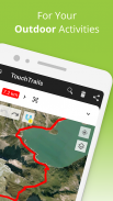
TouchTrails ist ein benutzerfreundlicher Routenplaner für alle deine Outdoor-Abenteuer. Zeichne deine Routen einfach mit deinem Finger in die Karte und erhalte präzise Entfernungsangaben und detaillierte Höhenprofile.
Plane Routen für deine nächste Radtour oder dein mehrtägiges Wanderabenteuer und lass dich dann Schritt für Schritt von der Sprachnavigation führen.
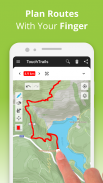
Plane deine Routen und passe sie für dich an
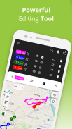
Mit deinem Finger kannst du nach Belieben Routen zeichnen. Die Snap-to-Road Funktion sorgt dafür, dass du auf dem richtigen Weg bleibst. Du hast aber auch die Möglichkeit, Routen komplett abseits von Straßen zu zeichnen. TouchTrails bietet dir die Werkzeuge, um Routen an deine Bedürfnisse anzupassen. Du kannst Routen zerteilen, löschen oder verbinden.
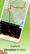
Entfernung und Höhenmeter
Genaue Entfernungsangaben und detaillierte Höhenprofile geben dir Informationen darüber, wie weit und wie hoch dich dein Abenteuer führen wird.
Wegpunkte hinzufügen und bearbeiten
Erweitere deine Karte mit Highlights, Tipps und interessanten Punkten. Für Wegpunkte gibt es eine umfangreiche Bibliothek an Symbolen mit denen du deine Karte individuell gestalten kannst.
GPS Tracker
Zeichne deine Erlebnisse mit dem GPS Tracker auf. Speichere, bearbeite oder teile sie mit Freunden.
GPX Viewer
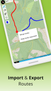
Du hast die perfekte Route im Internet gefunden? Importiere GPX-Dateien aus beliebigen Quellen. Navigiere entlang der Routen, miss die Entfernungen und analysiere Höhenprofile. Du kannst sie nach Belieben bearbeite.
Mehrere Routen auf einer Karte
Mit TouchTrails kannst du mehrere Routen gleichzeitig auf einer Karte anzeigen lassen. Du bist nicht auf eine einzige Route auf einer Karte limitiert. Die Flexibilität von TouchTrails ermöglicht es dir, Routen aus verschiedenen Quellen zu kombinieren und zu verbinden.
Routen teilen
Sende deine Routen an Freunde und teile deine Abenteuer mit ihnen.
TouchTrails ist die perfekte App für Routenplanung, GPS-Tracking und Navigation für alle Arten von Outdoor-Abenteuern, darunter:
• Laufen, Walken und Wandern
• Radfahren und Mountainbiking
• Motorradfahren
• Overlanding
• Skifahren
• Mantrailing
• und vieles mehr!
TouchTrails Premium
Upgrade auf TouchTrails Premium für noch mehr Leistung!
• Snap to road
◦ TouchTrails rastet direkt auf jeder Straße, jedem Radweg oder Wanderweg ein
• Turn-by-turn Navigation
◦ warnt dich, wenn du die Route verlässt
◦ Abbiegehinweise per Audio
• mehr als 100 Symbole um Wegpunkte anzupassen
• speichere eine unbegrenzte Anzahl von Routen
• GPX-Dateien exportieren
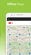
• Offline-Karten, verwende TouchTrails auch dann, wenn das Internet nicht verfügbar oder unzuverlässig ist
Für Support und Tipps besuche bitte
https://www.touchtrails.com/docs/user-guide
Installiere TouchTrails und erlebe unvergessliche Abenteuer! 🌲🚴🏃
TouchTrails: Routenplaner – Version 2.13.16
(07-06-2025)
TouchTrails: Routenplaner – APK Informationen
APK Version: 2.13.16Paket: com.wolfgangknecht.sketchatrackNeueste Version von TouchTrails: Routenplaner
Weitere Versionen


 4.15
4.15


Apps in derselben Kategorie


Das könnte dir auch gefallen...


